 EMODnet Product Catalogue
Northwest Atlantic Ocean (40W)
Type of resources
Available actions
Topics
Keywords
Contact for the resource
Provided by
Years
Representation types
-
The Universidad del Caribe responds to the demand for technical support for the elaboration of specific bathymetric charts for a polygon of 458 Ha that is located between the Isla Contoy National Park and Cayo Alcatraz. The objective was to make a bathymetric map of the polygon and point out the main characteristics or morphological features. Likewise, CTD cast were carried out to have a database with future application to mariculture, with the purpose of contributing to the economic development of communities in Quintana Roo through economic diversification and regional cultural identity and promoting fair trade and solidarity that favor the production and consumption of original products.This activities of the Node for the Promotion of the Social and Solidarity Economy (NODESS) called Selva, Mar y Comunidad Pre Registration Folio SINCA_PNSS_20_00009_INAES, made up of the Universidad del Caribe, Directorate of Economic Promotion of the H. Ayuntamiento of Lázaro Cárdenas, Muuch Kaab Cooperative, Cooperative University of Community Innovation, Mar de las Antillas Cooperative and Tianguis del Mayab. This technical report is at the request of the Cooperativa Mar de las Antillas. Important Note: This submission has been initially submitted to SEA scieNtific Open data Edition (SEANOE) publication service and received the recorded DOI. The metadata elements have been further processed (refined) in EMODnet Ingestion Service in order to conform with the Data Submission Service specifications.
-
Memorial University has over the past 15 years been involved in various ocean glider activities with deployments focused primarily on the Newfoundland Shelf and the Labrador Sea. For example, there are four deployments with glider data in the Labrador Sea. Partnerships with Fisheries and Oceans Canada and Ocean Gliders Canada have also resulted in deployments of Memorial's gliders in the Pacific. The data contain 14’663 mission kms, 620 deployment days and 25’108 individual glider profiles. L1 NETCDF files for every deployment archived on the Memorial University’s Glider Data server are made available publicly for scientific research. Deployments vary in duration and region. All files were processed with the SOCIB glider toolbox ((Troupin et al., 2015)-[https://doi.org/10.1016/j.mio.2016.01.001]), modified by Nicolai von Oppeln-Bronikowski, 2019 for MUN glider deployments. Metadata: File creator(s), contact info, institution, applicable funding, responsible researcher(s), deployment region, deployment start, deployment end, longitude min, longitude max, latitude min, latitude max, glider type, glider configuration if known, sensors, sensor serial numbers, science data QC. Glider Data: Minimum Data: Time, Depth, Position, Depth-Averaged Current, CTD. Most Deployments: Oxy_umolL, Oxy_Calphase_DEG, Oxy_sat Some Deployments: pCO2_uatm, pCO2_Calphase_DEG, pCO2_Dphase Important Note: This submission has been initially submitted to SEA scieNtific Open data Edition (SEANOE) publication service and received the recorded DOI. The metadata elements have been further processed (refined) in EMODnet Ingestion Service in order to conform with the Data Submission Service specifications.
-
Students and researchers at the University of the Caribbean together with members of the Cooperative Sea of ??the Antilles, conducted an oceanographic campaign at the site called cayo Alcatraz, where there are two underwater springs also known as “ojos de agua”. These springs are located within the polygon of the protected area of ??the Mexican Caribbean Biosphere Reserve, to the west of Isla Contoy National Park. The purpose of the campaign was to begin studies of the environmental conditions and reconnaissance of the site. The measuring instruments used were; SonTek CastAway-CTD, and a Gopro Black 7 camera. were made a set of 12 temperature, salinity, and conductivity profiles. Water samples were also taken for subsequent microbiological analysis. Important Note: This submission has been initially submitted to SEA scieNtific Open data Edition (SEANOE) publication service and received the recorded DOI. The metadata elements have been further processed (refined) in EMODnet Ingestion Service in order to conform with the Data Submission Service specifications.
-
Near-bottom multibeam bathymetry acquired at the French Antilles volcanic arc between Les Saintes et Dominica islands. High-resolution bathymetry data (1 m/pixel) were acquired by the autonomous underwater vehicle (AUV) AsterX, deployed during the 2017 Subsaintes cruise (https://doi.org/10.17600/17001000. The dataset consists of dives #394 through #404, after renavigation of the veichile. This dataset includes both grids of individual dives (bathymetry and backscatter, in GRD format), and mosaics combining these dives in 3 larger grids (GEOTIFF). All grids are provided in WGS 84 projection. Important Note: This submission has been initially submitted to SEA scieNtific Open data Edition (SEANOE) publication service and received the recorded DOI. The metadata elements have been further processed (refined) in EMODnet Ingestion Service in order to conform with the Data Submission Service specifications.
-
Dataset contains bottom temperature data from both fixed and mobile gear types (e.g. traps, trawlers, scallopers, long-liners) in the Gulf of Maine and the South New England Bight. The time series begins in 2015 and runs in real-time until today. The water depths range from 1- 900 meters. The variability associated with tidal, wind, seasonal, and inter-annual processes can be depicted at nearly all sites in this multi-year time series. This data was collected as part of the Environmental Monitors on Lobster Traps (eMOLT) project - a non-profit collaboration of industry, science and academics devoted to the monitoring of the physical environment of the Gulf of Maine and the Southern New England Shelf. Important Note: This submission has been initially submitted to SEA scieNtific Open data Edition (SEANOE) publication service and received the recorded DOI. The metadata elements have been further processed (refined) in EMODnet Ingestion Service in order to conform with the Data Submission Service specifications.
-
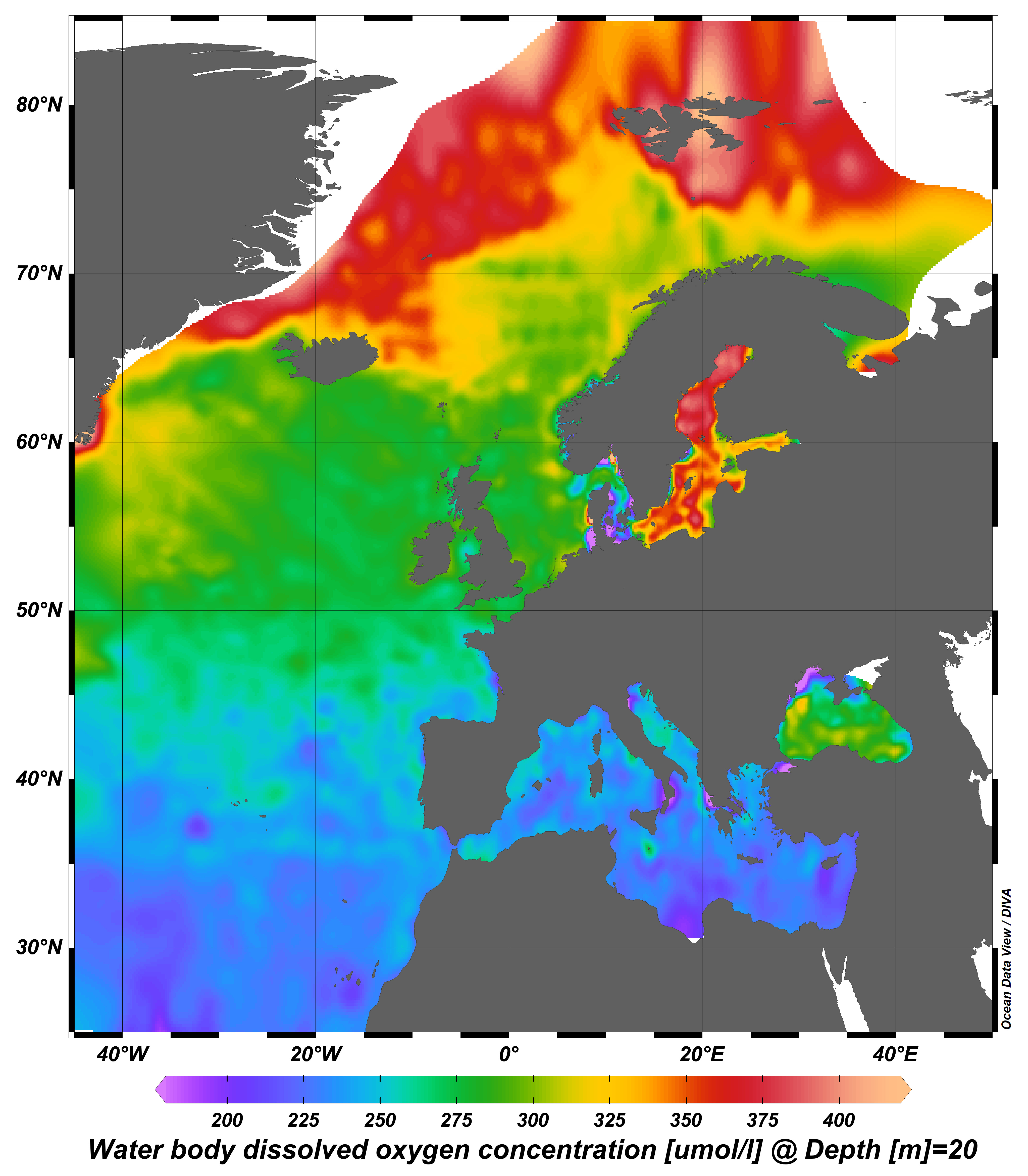
webODV visualisations via WMS from the harmonized, standardized, validated data collections that EMODnet Chemistry is regularly producing and publishing for all European sea basins for eutrophication and contaminants. You can analyze, visualize, subset and download EMODnet Chemistry data using interactive webODV services. More information at: https://emodnet.ec.europa.eu/en/chemistry#chemistry-services
-
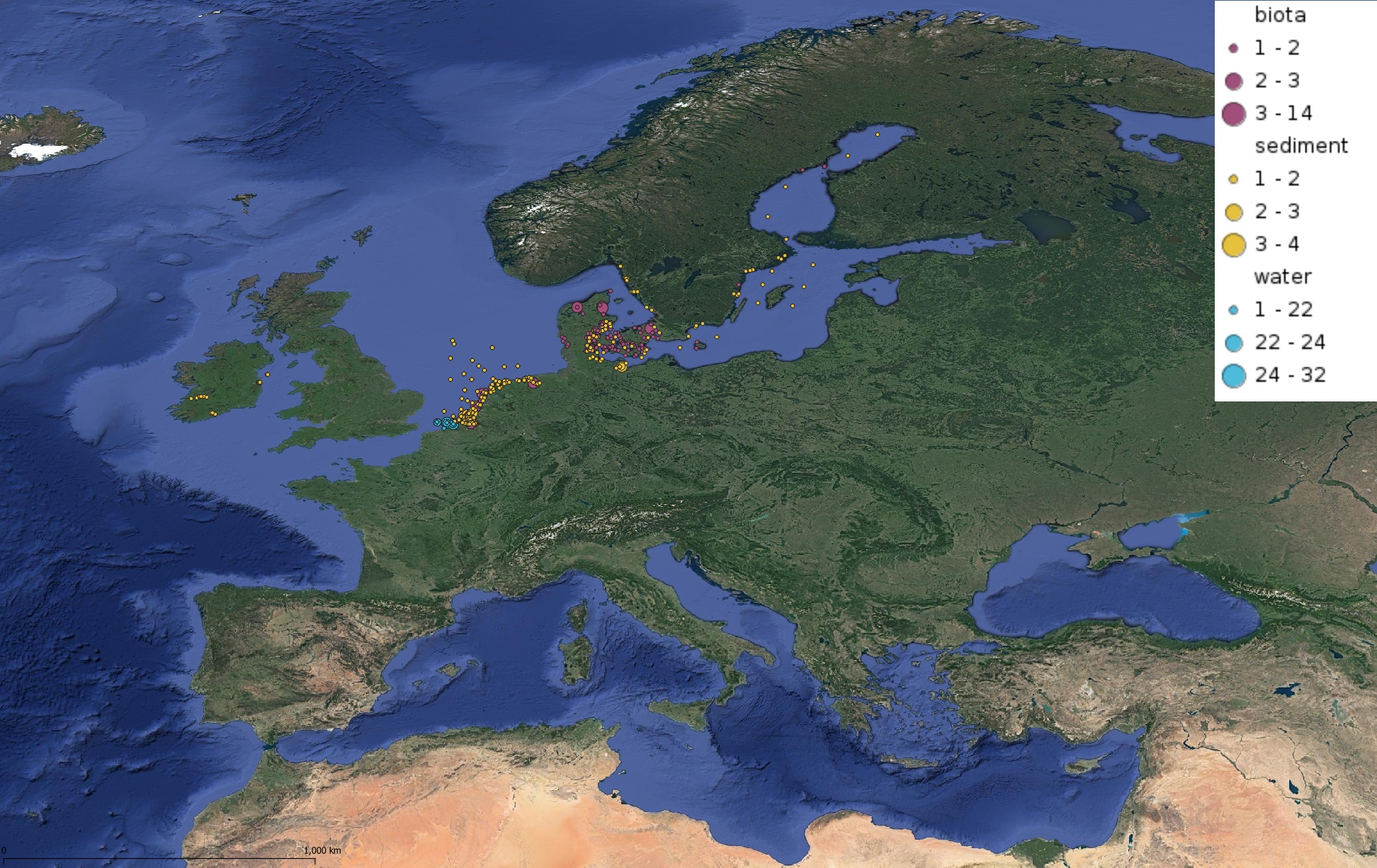
This product displays for Triphenyltin, positions with values counts that have been measured per matrix and are present in EMODnet validated datasets. The product displays positions for all available years and per year.
-
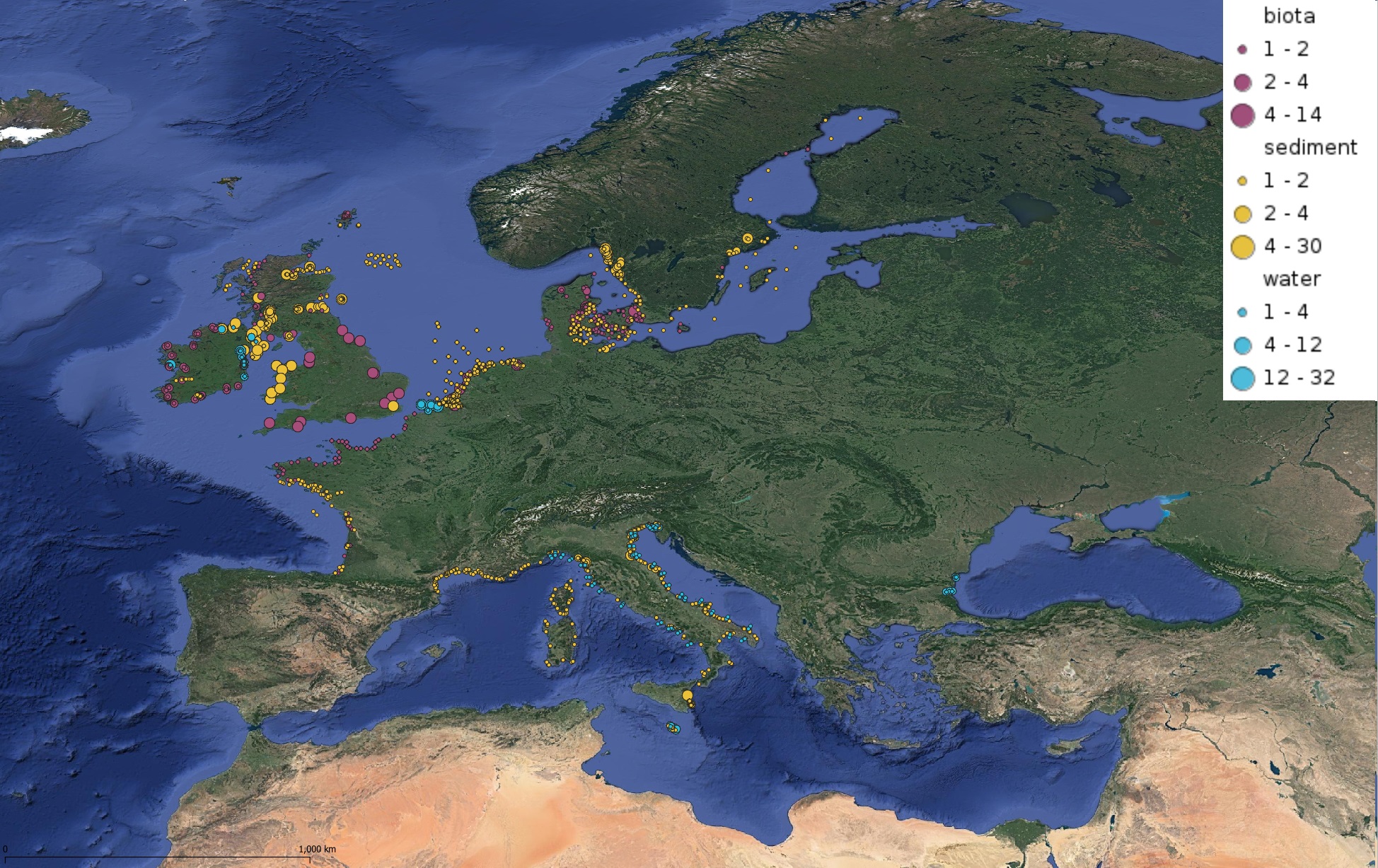
This product displays for Tributyltin, positions with values counts that have been measured per matrix and are present in EMODnet validated datasets. The product displays positions for all available years and per year.
-
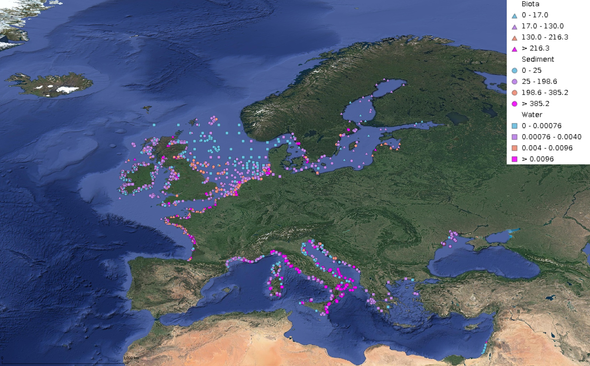
This product displays for Mercury, median values of the last 6 available years that have been measured per matrix and are present in EMODnet validated datasets. The median values ranges are derived from the following percentiles: 0-25%, 25-75%, 75-90%, >90%. Only "good data" are used, namely data with Quality Flag=1, 2, 6, Q (SeaDataNet Quality Flag schema). For water, only surface values are used (0-15 m), for sediment and biota data at all depths are used.
-
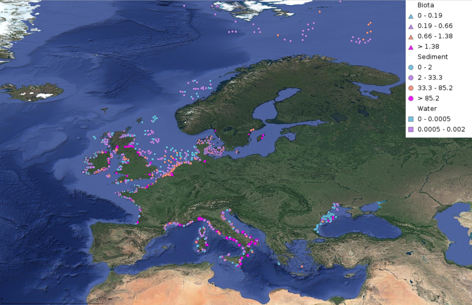
This product displays for Benzo(a)pyrene, median values of the last 6 available years that have been measured per matrix and are present in EMODnet validated datasets. The median values ranges are derived from the following percentiles: 0-25%, 25-75%, 75-90%, >90%. Only "good data" are used, namely data with Quality Flag=1, 2, 6, Q (SeaDataNet Quality Flag schema). For water, only surface values are used (0-15 m), for sediment and biota data at all depths are used.